Explore This Trek In Details
Version: Standard 19D/18N
19 Days / 18 Nights Strenuous Minimum Altitude: 1980m Maximum Altitude: 5250m Starts At: Sari Ends At: Rishikesh
Route
Sari → Chopta → Deoria Tal (excursion) → Ransi → Tungnath, Chandrashila (excursion) → Gaundhar → Bantoli → Nanu Chatti → Kun Chatti → Madhyameshwar → Kachni Dhar → Pandavsera → Nandi Kund → Ghiya Vinayak Pass (pass crossing) → Barma Bugiyal → Matigair → Dhing → Kalpeshwar Temple (excursion) → Kalgoat → Rudranath → Panar Bugyal → Toli Bugyal → Kalpeshwar → Gaurikund → Kedarnath → Gaurikund → Rishikesh
Terrain
Alpine MeadowsBouldersScree
17 Trekking Days
12 Camping | 6 Hotel | 1 Homestay Nights
1 Pass Crossing | 1 Contingency Days
135 Km Trekking Distance | 0 Km Driving Distance
Trekking avg 6.00 hrs
▲ Day 1 Arrive in SariArrival Day
Arrive In Sari
Overnight In: Sari (1980m / 6496 ft )
Accommodation: Hotel
Meals Included: Evening Tea Snacks, Soup, Dinner, Dessert, Hot Drinks
Today we pick you up in the morning after breakfast and take on the beautiful drive to Ukhimath and then to Sari. On reaching, we check-in to the hotel and then rest for the remainder of the day. Sari is a peaceful little village. You must take time out to explore it.
- Day 1
- 320 - Rishikesh
- Day 1
- 1310 - Ukhimath
- Day 1
- 1980 - Sari
180Km, 7hrs.▲ Day 2 Explore Deoria TalExploration Day
From Sari (1980m / 6496 ft ) To Chopta (2600m / 8530 ft ). Excursion To Deoria Tal (2450m / 8038 ft ) And Return To Chopta (2600m / 8530 ft ) - 5 Hrs.
Overnight In: Chopta (2600m / 8530 ft )
Accommodation: Hotel
Meals Included: Morning Tea, Breakfast, Lunch, Evening Tea Snacks, Soup, Dinner, Dessert, Hot Drinks
Today early morning we start our 1-hour trek to Deoria Tal from Sari to make sure we reach there at the time of sunrise to enjoy the dawn view. After spending enough time captivating the views and taking photos, we trek back to Sari. After that, we drive to Chopta which takes about 2 hours. On reaching Chopta, we firstly check-in to our hotel and then set out to walk around the village. We can do the Chandrashila Summit today itself, but we would rather keep it for sunrise time.
- Day 2
- 1980 - Sari
- Day 2
- 2600 - Chopta
- Day 2
- 2450 - Deoria Tal
- Day 2
- 2600 - Chopta
5hrs.▲ Day 3 Explore Tungnath, ChandrashilaExploration Day
From Chopta (2600m / 8530 ft ) To Ransi (2000m / 6562 ft ). Excursion To Tungnath, Chandrashila (4000m / 13123 ft ) And Return To Ransi (2000m / 6562 ft ) - 7 Hrs.
Overnight In: Ransi (2000m / 6562 ft )
Accommodation: Homestay
Meals Included: Morning Tea, Breakfast, Lunch, Evening Tea Snacks, Soup, Dinner, Dessert, Hot Drinks
Today, we start our day a little before dawn to enable us to enjoy the dawn from the ridge top. It takes about 2.5 hours to reach the temple of Tungnath and then to the top of the Chandrashila Peak. The summit of Chandrashila peak offers a wide array of some of the popular peaks of the Garhwal Himalayas including the likes of Nanda Devi. After spending enough time to satiate ourselves with the views of the panorama of peaks and surrounding valleys, we head back to Chopta and drive to Ransi. Its a 3 hour drive to Ransi from Chopta.
- Day 3
- 2600 - Chopta
- Day 3
- 2000 - Ransi
- Day 3
- 4000 - Tungnath, Chandrashila
- Day 3
- 2000 - Ransi
7hrs.▲ Day 4 From Ransi to BantoliTrek Day
From Ransi (2100m / 6890 ft ) To Bantoli (2700m / 8858 ft ) Via Gaundhar (2850m / 9350 ft ) - 4-5 Hrs. 8 Kms
Overnight In: Bantoli (2700m / 8858 ft )
Accommodation: Camping
Meals Included: Morning Tea, Breakfast, Lunch, Evening Tea Snacks, Soup, Dinner, Dessert, Hot Drinks
Today is the starting day of our Nandi Kund - Ghiya Vinayak Pass Trek. We head towards Bantoli from Ransi and its a very scenic trek. The village and religious life of the high altitude villages of Uttrakhand is on display throughout the trek route. Being a popular pilgrimage route, the route is chirpy as well with full of vivid colours and life.
The trek is more or less easier getting steeper at times. We get enough option to have our lunch and little snacks enroute Bantoli. Gaundhar is a point we come across on the route very near to Bantoli on the Nandi Kund - Ghiya Vinayak Pass Trek. It is here where the Madhyamaheshwar Ganga and Markanda Ganga meets, with a lovely looking small bridge over it. Little more on the route and we reach Bantoli, our halt for the night.
We have quite a few options to settle in one of the homestays on offer. If not, we pitch our small tents somewhere. Hot dinner awaits us and with this, the first day of our trek to Nandi Kund and Ghiya Vinayak Pass ends.
- Day 4
- 2100 - Ransi
- Day 4
- 2850 - Gaundhar
- Day 4
- 2700 - Bantoli
8Km, 4 - 5hrs.▲ Day 5 From Bantoli to MadhyameshwarTrek Day
From Bantoli (2700m / 8858 ft ) To Madhyameshwar (3500m / 11483 ft ) Via Nanu Chatti (2720m / 8924 ft ), Kun Chatti (2780m / 9121 ft ) - 4-5 Hrs. 8 Kms
Overnight In: Madhyameshwar (3500m / 11483 ft )
Accommodation: Camping
Meals Included: Morning Tea, Breakfast, Lunch, Evening Tea Snacks, Soup, Dinner, Dessert, Hot Drinks
We are into the second day into our trek to Nandi Kund and Ghiya Vinayak Pass. Madhyamaheshwar is one of the panch kedars and is one of the popular and highly rated pilgrimage route for the Hindus. The trek route crosses Nanu Chatti just after some time into the trek. It the passes by Maikhamba and Kun Chatti, from where its a good walk for some 3 hours to bring us to the shrine of Madhyamaheshwar.
Post lunch, we go on for a acclimatization walk to Buda Madhyamaheshwar. If lucky, we might catch a glimpse of Chowkhambha in a small water body near Buda Madhyamaheshwar.
Our route for tomorrow to Kachni Khal is visible and inspires enough motivation in us to take the challenge. Post dinner, we wish good night to each other and get into our cozy sleeping bags.
- Day 5
- 2700 - Bantoli
- Day 5
- 2720 - Nanu Chatti
- Day 5
- 2780 - Kun Chatti
- Day 5
- 3500 - Madhyameshwar
8Km, 4 - 5hrs.▲ Day 6 From Madhyamaheshwar to Kachni DharTrek Day
From Madhyamaheshwar (3500m / 11483 ft ) To Kachni Dhar (4400m / 14436 ft ) - 5-6 Hrs. 9 Kms
Overnight In: Kachni Dhar (4400m / 14436 ft )
Accommodation: Camping
Meals Included: Morning Tea, Breakfast, Lunch, Evening Tea Snacks, Soup, Dinner, Dessert, Hot Drinks
Today our trek to Nandi Kund takes a drastic change, both in the form of difficulties of the climb, and the solitude of the trail.
After waking up to a lovely morning in the blessed site of Madhyamaheshwar, we get ready to tackle the day's trek. It involves a steep continuous climb to the Kachni Khal marked typically by 2 huge rocks forming a gateway.
An arduous climb of some 4 - 5 hours gets us to the top of Kachni Khal. From here, the trail forks and one goes left towards Kedarnath, other to Panpatia and the route on the right goes towards Nandi Kund. Our campsite is a rocky patch today with great views of Chowkhamba.
Evening, we take a light acclimatization walk to Kachni Khal and return to our campsite
- Day 6
- 3500 - Madhyamaheshwar
- Day 6
- 4400 - Kachni Dhar
9Km, 5 - 6hrs.▲ Day 7 From Kachni Dhar to PandavseraTrek Day
From Kachni Dhar (4400m / 14436 ft ) To Pandavsera (4100m / 13451 ft ) - 5-6 Hrs. 9 Kms
Overnight In: Pandavsera (4100m / 13451 ft )
Accommodation: Camping
Meals Included: Morning Tea, Breakfast, Lunch, Evening Tea Snacks, Soup, Dinner, Dessert, Hot Drinks
The trek for today leaves behind all signs of civilization and follows an unmarked shepherd's trail to reach Pandavsera. A very efficient local guide is much required here. We trek through bushes and cross the Madhyamaheshwar nala multiple times and pass by few small waterfalls to reach a flat meadow. This is marked as Pandavsera and we camp here for the night, by the stream.
- Day 7
- 4400 - Kachni Dhar
- Day 7
- 4100 - Pandavsera
9Km, 5 - 6hrs.▲ Day 8 From Pandavsera to Nandi KundTrek Day
From Pandavsera (4100m / 13451 ft ) To Nandi Kund (4800m / 15748 ft ) - 3 Hrs. 6 Kms
Overnight In: Nandi Kund (4800m / 15748 ft )
Accommodation: Camping
Meals Included: Morning Tea, Breakfast, Lunch, Evening Tea Snacks, Soup, Dinner, Dessert, Hot Drinks
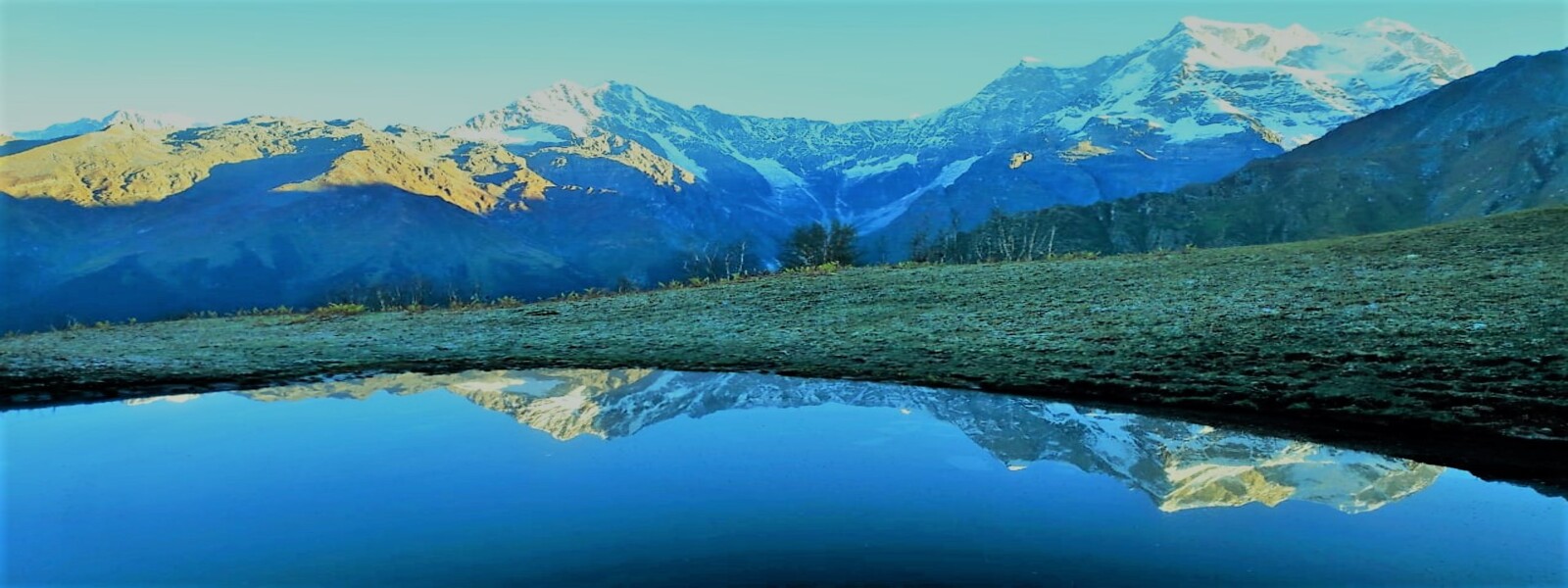
The trail to Nandi Kund from Pandavsera follows the small stream of Madhyamaheshwar Nala emerging out from Nandi Kund. It's a gradual climb that gets steeper at times. The rough terrain presents its own challenges. We cross the Madhyamaheshwar Nala multiple times and then climb up steep for another hour to reach the serene Nandi Kund. The peaceful lake and its tranquil waves take our hearts right away and lower down our energy injecting immense peace in us and give us divine happiness and satisfaction. This is why we travel to the difficult parts of the Himalayas for!The entire view of the surrounding is so beautiful that simpler words which I know fail to do justice to the actual beauty of the place. The peaks of Chowkhamba hovers over the lake. The name of the Lake is derived from Nandi - The name of the Bull which was actually Lord Shiva in disguised avatar hiding away from the Pandavas, who were seeking mercy and moksha (liberation from the cycle of life and death as per the Hindu belief) from Lord Shiva after the war of Kurukshetra. We spend the remaining part of the day relinquishing the beautiful place that we are in with no one around to disturb. No noise, no disturbances from unwanted people around, no mobile, no internet. Just us and Mother Nature in its heavenly best.
- Day 8
- 4100 - Pandavsera
- Day 8
- 4800 - Nandi Kund
6Km, 3hrs.▲ Day 9 Cross Ghiya Vinayak PassPass Crossing Day
Cross Ghiya Vinayak Pass And Reach Barma Bugiyal (4100m / 13451 ft ) - 5-6 Hrs. 8 Kms
Overnight In: Barma Bugiyal (4100m / 13451 ft )
Accommodation: Camping
Meals Included: Morning Tea, Breakfast, Lunch, Evening Tea Snacks, Soup, Dinner, Dessert, Hot Drinks
Today is the highlight day of our trek as we cross the mighty Ghiya Vinayak Pass to topple over to the other side of the valley. It will be a long tiring day today. We can cut out the chances of bad weather hitting us on this hard terrain by starting the day as early as we can. A steep continuous climb for about 3 hours from Nandi Kund will take us to the top of the mighty Ghiya Vinayak Pass. The views from the top of the Ghiya Vinayak pass is just breathtaking. The coveted peaks of Chowkhamba, Neelkantha and Nanda Devi are visible on a clear day. The glacier table of the Panpatia too is visible from here.Weather permitting, we will spend a good time enjoying the views from the top of the Ghiya Vinayak Pass. After that, we will soon find ourselves negotiating the very steep descend to the lush green valley on the other side of the Ghiya Vinayak pass. It's the beautiful meadow of the Barmna Bugiyal on the other side of the pass. We lose altitude rapidly and in about an hour and a half we reach our designated campsite for the night. It will be a long rewarding day today and we will complete the 2 important missions of this trek - The Serene and Pious Lake Of Nandi Kund and Crossing the Mighty Pass Of Ghiya Vinayak. This being done, the remaining days of the trek are just about taking ourselves back to civilization. The remaining part of the trek still remains very beautiful though, as it passes through some untouched meadows and beautiful villages of the Garhwal Himalayas.
- Day 9
- 4800 - Nandi Kund
- Day 9
- 5250 - Ghiya Vinayak Pass
- Day 9
- 4100 - Barma Bugiyal
8Km, 5 - 6hrs.▲ Day 10 From Barma Bugiyal to MatigairTrek Day
From Barma Bugiyal (4100m / 13451 ft ) To Matigair (3500m / 11483 ft ) - 5-6 Hrs. 10 Kms
Overnight In: Matigair (3500m / 11483 ft )
Accommodation: Camping
Meals Included: Morning Tea, Breakfast, Lunch, Evening Tea Snacks, Soup, Dinner, Dessert, Hot Drinks
Will write later
- Day 10
- 4100 - Barma Bugiyal
- Day 10
- 3500 - Matigair
10Km, 5 - 6hrs.▲ Day 11 Explore Kalpeshwar TempleExploration Day
From Matigair (3500m / 11483 ft ) To Dhing (3200m / 10499 ft ). Excursion To Kalpeshwar Temple (2200m / 7218 ft ) And Return To Dhing (3200m / 10499 ft ) - 4-5 Hrs. 8 Kms
Overnight In: Dhing (3200m / 10499 ft )
Accommodation: Hotel
Meals Included: Morning Tea, Breakfast, Lunch, Evening Tea Snacks, Soup, Dinner, Dessert, Hot Drinks
Will write later
- Day 11
- 3500 - Matigair
- Day 11
- 3200 - Dhing
- Day 11
- 2200 - Kalpeshwar Temple
- Day 11
- 3200 - Dhing
8Km, 4 - 5hrs.▲ Day 12 From Dhing to RudranathTrek Day
From Dhing (3200m / 10499 ft ) To Rudranath (3600m / 11811 ft ) Via Kalgoat (2200m / 7218 ft ) - 5-6 Hrs. 16 Kms
Overnight In: Rudranath (3600m / 11811 ft )
Accommodation: Camping
Meals Included: Morning Tea, Breakfast, Lunch, Evening Tea Snacks, Soup, Dinner, Dessert, Hot Drinks
Will write later
- Day 12
- 3200 - Dhing
- Day 12
- 2200 - Kalgoat
- Day 12
- 3600 - Rudranath
16Km, 5 - 6hrs.▲ Day 13 From Rudranath to Panar BugyalTrek Day
From Rudranath (3600m / 11811 ft ) To Panar Bugyal (3340m / 10958 ft ) - 5-6 Hrs. 13 Kms
Overnight In: Panar Bugyal (3340m / 10958 ft )
Accommodation: Camping
Meals Included: Morning Tea, Breakfast, Lunch, Evening Tea Snacks, Soup, Dinner, Dessert, Hot Drinks
Will write later
- Day 13
- 3600 - Rudranath
- Day 13
- 3340 - Panar Bugyal
13Km, 5 - 6hrs.▲ Day 14 From Panar to KalpeshwarTrek Day
From Panar (3340m / 10958 ft ) To Kalpeshwar (2200m / 7218 ft ) Via Toli Bugyal (2900m / 9514 ft ) - 3-4 Hrs. 8 Kms
Overnight In: Kalpeshwar (2200m / 7218 ft )
Accommodation: Camping
Meals Included: Morning Tea, Breakfast, Lunch, Evening Tea Snacks, Soup, Dinner, Dessert, Hot Drinks
Will write later
- Day 14
- 3340 - Panar
- Day 14
- 2900 - Toli Bugyal
- Day 14
- 2200 - Kalpeshwar
8Km, 3 - 4hrs.▲ Day 15 From Kalpeshwar to GaurikundTrek Day
From Kalpeshwar (2200m / 7218 ft ) To Gaurikund (2200m / 7218 ft ) - 7 Hrs.
Overnight In: Gaurikund (2200m / 7218 ft )
Accommodation: Hotel
Meals Included: Morning Tea, Breakfast, Lunch, Evening Tea Snacks, Soup, Dinner, Dessert, Hot Drinks
Will write later
- Day 15
- 2200 - Kalpeshwar
- Day 15
- 2200 - Gaurikund
7hrs.▲ Day 16 From Gaurikund to KedarnathTrek Day
From Gaurikund (2200m / 7218 ft ) To Kedarnath (3550m / 11647 ft ) - 6-7 Hrs. 16 Kms
Overnight In: Kedarnath (3550m / 11647 ft )
Accommodation: Camping
Meals Included: Morning Tea, Breakfast, Lunch, Evening Tea Snacks, Soup, Dinner, Dessert, Hot Drinks
Will write later
- Day 16
- 2200 - Gaurikund
- Day 16
- 3550 - Kedarnath
16Km, 6 - 7hrs.▲ Day 17 From Kedarnath to GaurikundTrek Day
From Kedarnath (3550m / 11647 ft ) To Gaurikund (2200m / 7218 ft ) - 6-7 Hrs. 16 Kms
Overnight In: Gaurikund (2200m / 7218 ft )
Accommodation: Hotel
Meals Included: Morning Tea, Breakfast, Lunch, Evening Tea Snacks, Soup, Dinner, Dessert, Hot Drinks
Will write later
- Day 17
- 3550 - Kedarnath
- Day 17
- 2200 - Gaurikund
16Km, 6 - 7hrs.▲ Day 18 From Gaurikund to RishikeshTrek Day
From Gaurikund (2200m / 7218 ft ) To Rishikesh (300m / 984 ft ) - 8 Hrs.
Overnight In: Rishikesh (300m / 984 ft )
Accommodation: Hotel
Meals Included: Morning Tea, Breakfast, Lunch, Evening Tea Snacks, Soup, Dinner, Dessert, Hot Drinks
Drive to Rishikesh
- Day 18
- 2200 - Gaurikund
- Day 18
- 300 - Rishikesh
8hrs.▲ Day 19Flexible Contingency / Exploratory / Recovery Day
Flexible contingency day for weather or operational needs. Exploratory day if no contingencies.
Planned reserve day for weather, delays or operational needs. If unused, it may be spent more flexibly on route.
- Day 19
- 25 - Rest Day
- Day 19
- 25 - Rest Day 22
1hrs.
Other Customizable Variations of the Panch Kedar Trek
We are not limited to just these options. These are simply some of the most commonly requested and well planned customizations.
If you have a different requirement, talk to us.
We only organize lesser done, uncrowded, customizable and personalized, small-group private trekking tours in the Himalayas with full safety protocol in place. All customizations will be guided by this principle only.
Swipe →
Top Reasons to Choose the Panch Kedar Trek
- The mythological story around the establishment of Panch Kedar is very fascinating. It is believed that the Pandavas after the war of Kurukshetra felt very guilty of killing their own kins and brahmans. They were seeking the mercy of Lord Shiva, who was angry with them and was hiding and running away from the Pandavas. Shivji in order to hide from the Pandavas had taken the form of a bull named Nandi. In Guptkashi, Bhima recognized the bull as Shiva. However, Lord Shiva disappeared and the bull burst split into 5 parts which fell in 5 different locations. Later the Pandavas established 5 temples in all these 5 locations to be collectively named the Panch Kedars, meaning 5 Shivas. These locations are Madhmaheshwar where the navel of the bull is supposed to have fallen, Tungnath where his limbs fell, Kalpeshwar, where hairs fell, Rudranath, where face fell and finally Kedarnath where the hump of the bull fell.
- Apart from religious significance, the architecture, construction and location of these temples draw tremendous curiosity and fascination.
- The lakes of Deoria Tal, Buda Madhyamaheshwar and Nandi Kund are the ultimate serene lakes situated at an altitude of 4000 meters. The turquoise hues of the waters of Nandi Kund surrounded all around by rocky barren mountains will certainly blow off your mind in appreciation of Mothe Nature.
- The mountain massif of Chowkhamba lures you and gets you lost in its vastness and beauty.
- The peak of Chandrashila offers a grand panorama of many popular peaks of the Garhwal Himalayas including the revered Nanda Devi, Dunagiri, Hathi, Gauri, Trishul, Kedarnath, Chowkhamba among many others.
- The temple of Kedarnath needs no introduction to anyone who keeps knowledge of the Indian Himalayas and the culture of India. It is one of the most pious temples of the Hindus.
- These valleys are home to myriads of wildflowers, wild berries and rhododendrons. The alpine meadows of the high altitude and dense jungles are home to many wildlife including the likes of Himalayan Black Bear and the feared Leopard.
- This trek itinerary gives you a good amount of time to understand the Garhwali culture and its rich heritage. It offers you a good time to enjoy the Garhwali Hospitality and cuisines in their authentic and raw forms.
Altitude and Acclimatization Profile For The Panch Kedar Trek
- Day 1
- D1Rishikesh
- Day 1
- Ukhimath
- Day 2
- D2Sari
- Day 2
- Chopta
- Day 2
- Deoria Tal
- Day 3
- D3Chopta
- Day 3
- Ransi
- Day 3
- Tungnath, Chandrashila
- Day 4
- D4Ransi
- Day 4
- Gaundhar
- Day 5
- D5Bantoli
- Day 5
- Nanu Chatti
- Day 5
- Kun Chatti
- Day 6
- D6Madhyameshwar
- Day 7
- D7Kachni Dhar
- Day 8
- D8Pandavsera
- Day 9
- D9Nandi Kund
- Day 9
- Ghiya Vinayak Pass
- Day 10
- D10Barma Bugiyal
- Day 11
- D11Matigair
- Day 11
- Dhing
- Day 11
- Kalpeshwar Temple
- Day 12
- D12Dhing
- Day 12
- Kalgoat
- Day 13
- D13Rudranath
- Day 14
- D14Panar Bugyal
- Day 14
- Toli Bugyal
- Day 15
- D15Kalpeshwar
- Day 16
- D16Gaurikund
- Day 17
- D17Kedarnath
- Day 18
- D18Gaurikund
- Day 19
- D19Rishikesh
- Day 20
- Rest Day 22
Frequently Asked Questions
What is the best time to do the Panch Kedar Trek?
Best months: May, Jun, Jul, Sep, Oct
Is mobile network available on the Panch Kedar Trek?
Quick answer: Jio, BSNL, Airtel Sparsely on trek, prominently on trek bases
Is internet available on the Panch Kedar Trek?
Quick answer: Mobile internet available sparsely on trek
What is the accommodation type on this trek?
Camping / Homestay
Camping/Homestay treks are a mixed style where some nights are spent in tents and some in village homestays or basic guesthouses. This balance offers both wilderness camping experience and cultural immersion with local hospitality. Comfort and facilities vary by village and season.
What kind of toilet facilities can I expect on this trek?
A mix of homestay toilets (where available) and toilet tents at campsites. Facilities vary by village; camping nights usually rely on toilet tents or designated pits.
How is food served during the trek?
Food is served based on the night’s arrangement: fresh cooked meals by trek staff during camping nights and home-style local meals during homestay nights. Meal style and variety depend on package and village logistics.
How is human waste managed on this trek?
Handled via village toilet systems during homestays and toilet tents/pits during camping nights. Strict separation from water sources is maintained during camping.
How is food waste managed on this trek?
Food waste is minimized and handled responsibly. In villages, it follows local disposal norms; during camping, biodegradable waste is managed away from water sources or carried out as required.
How is plastic waste handled on this trek?
Plastic is segregated and carried back to the roadhead for disposal. Trekkers should avoid single-use plastics and carry personal waste.
How do you follow Leave No Trace principles on this trek?
Combination of campsite discipline and village-respect practices: no littering, low noise, water source protection, and respect for local customs and private property. Waste is segregated and carried out wherever local disposal is unreliable.
What type of terrain can I expect on the Panch Kedar Trek?
Alpine Meadows, Scree, Boulders
Is cloakroom / luggage storage available for the Panch Kedar Trek?
No. Cloakroom or luggage storage is not available for this trek.
What kind of food is served on the Panch Kedar Trek?
Indian, Garhwali, Nepali
We serve a mix of continental-style trek meals as well as simple, freshly cooked home-style food.
The exact menu and style of meals may vary depending on the trek itinerary, region, and the package you are booked on.
Meal inclusions typically cover:
- Breakfast, Lunch, and Dinner (BLD)
- Two tea breaks daily (morning and evening)
- Soup in the evening
- Fresh salads where feasible
- Dessert on select days
- Hot night beverage / tonic before sleeping
Please note that detailed, day-wise meal information is mentioned in the respective day’s itinerary wherever applicable.
Where does the Panch Kedar Trek start?
Where does the Panch Kedar Trek end?
What is the grade / difficulty of the Panch Kedar Trek?
Strenuous
The trek duration each day may span from 5 - 8 hours, and may go up to to 8 - 9 on few days. The trail involves steep ascents and descents. Good fitness are demand of these treks, and trekkers must involve themselves in cardio exercises regularly to do these treks comfortably. Sleeping altitude may go above 4000 meters or little above it on couple of days, but not more than that. The trail might go as high as 4500 - 5200 meters. These trek are remote and evacuation might not be possible from all the campsites
What is the duration of the Panch Kedar Trek?
20 Days, Rishikesh to Rishikesh
Is the Panch Kedar Trek inside or near a national park?
Kedarnath Wildlife Sanctuary
Thursday, June 11, 2026 2:44:22 PM